This morning we assembled
the food provided in our hotel kitchenette for a nice breakfast of fried eggs,
English muffins, cereal, and fruit.
By 9:30 am we were packed up and heading south on the Haines Highway, a road running through Kluane National Park, between Haines Junction, Yukon and Haines, Alaska. Our intention was to drive about 100 km down the Haines Highway, to around the BC border, checking out interesting lakes and trails along the way, before doubling back through Haines Junction en route to Whitehorse.
By 9:30 am we were packed up and heading south on the Haines Highway, a road running through Kluane National Park, between Haines Junction, Yukon and Haines, Alaska. Our intention was to drive about 100 km down the Haines Highway, to around the BC border, checking out interesting lakes and trails along the way, before doubling back through Haines Junction en route to Whitehorse.
The Haines Highway scenery
is much like that surrounding Haines Junction – high mountains reaching above
the tree line, with rugged snowy tops. With the first yellows and oranges of
autumn appearing on the slopes and the spent roadside purple loostrife turning
pink and crimson, late August is a particularly picturesque time to visit.
Our first stop was Kathleen
Lake, a large clear green glacier-fed lake, surrounded by high mountains. We
learned from interpretive signs that the lake is an important habitat for land-locked
sockeye salmon, called “kokanee” salmon. We walked along a lakeshore boardwalk
on the 0.5-km Kokanee Trail, then continued for a short ways along the pebble
beach.
Our next stop was Dezadeash Lake, a larger body of water which resembled a perfect plane mirror. We walked around a bit on the beach by the lakefront campground.
We proceeded on to Klukshu, a traditional First Nation salmon fishing village on the bank of Klukshu Creek. The little village consists of around twenty wooden houses and it appears that its economy still centres around the salmon run. We read the interpretive signs on the creekside describing the fishing and curing processes and even spotted a couple of beautiful red sockeye spawn in the creek. As always we were also on the lookout for grizzlies (they are lured by the salmon, making Klukshu Creek one of their most frequented areas!).
We proceeded on to Klukshu, a traditional First Nation salmon fishing village on the bank of Klukshu Creek. The little village consists of around twenty wooden houses and it appears that its economy still centres around the salmon run. We read the interpretive signs on the creekside describing the fishing and curing processes and even spotted a couple of beautiful red sockeye spawn in the creek. As always we were also on the lookout for grizzlies (they are lured by the salmon, making Klukshu Creek one of their most frequented areas!).
 |
| Klukshu fishing village |
 |
| Klukshu Creek |
We pulled over for lunch at
a rest stop with a wooden platform overlooking the wide valley and surrounding mountains.
A few kilometres down the
highway we stopped at the Million Dollar Falls campground to take a walk out on
the boardwalk overlooking this Takhanne River waterfall. From the head of the
trail we could already hear the roar of the water; a couple minutes later we had
descended the boardwalk stairs to see a narrow plume of white crashing through
the bottom of a rocky gorge, the force of the falling water sending droplets of
spray dancing up a few feet above the waterline. The falls were interesting to visit and resembled
the Englishman River ones on Vancouver Island.
We drove several more kilometres until the highway began descending, just north of the BC-Yukon border, then turned around.
On the way back north
towards Haines Junction, we stopped at a couple of other sights that we’d missed
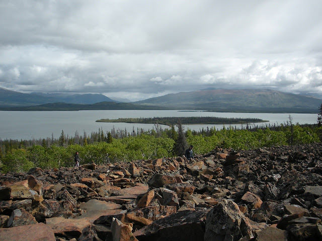
heading south. The Rock Glacier Interpretive Trail was one of the most
interesting stops of the day. A 1.6-km path led us over boardwalks through a
marshy area, down a trail through a spruce and poplar forest, and up 300-m onto
the toe of the rock glacier. Interpretative signs along the trail explained
that a rock glacier is not a moraine, as we’d initially assumed; rather it is a
mass of talus that falls from the valley walls onto the top of the glacial ice,
particularly as the glacier begins to shrink, and remains after the ice has melted. The
rock fragments were angular (possibly shale) and a rusty red from alpine lichen.
It was fun scrambling up them on a little path, to a little fort of stacked rocks
with wooden benches. Beyond this point the official trail ended, though
visitors could continue hiking up the slope to the remnants of the glacier – we
decided not to and were happy to admire the view of Dezadeash Lake for a bit
before walking back down.
We drove several more kilometres until the highway began descending, just north of the BC-Yukon border, then turned around.
 |
| turnaround point |
We headed back through
Haines Junction, stopping to take a photo of the kitsch Village Monument wildlife sculpture,
nicknamed “The Muffin” by locals. After a pitstop at the Haines Junction
Visitors’ Centre we made the two-hour drive back east along the Alaska Highway,
to Whitehorse.
After a week of cooking our own meals, we enjoyed dinner at KFC, followed by coffees at Starbucks, while having a last look around Whitehorse. By 10 pm we had returned our rental car and were settled for a few hours’ rest in the airport, before a very early flight back to Vancouver.
 |
| mountain goat, dall sheep, and moose emerging from the mountainside atop The Muffin |
 |
| The Muffin is not the only unique art in Haines Junction -- a street sign decorated with caribou, moose, and dall sheep antlers |


so pretty!
ReplyDelete